 Pressmediaofindia
Related Articles



The actual present status of the 82 acres and 27 guntas of Kohe Imam Zamin land can be established only through a fresh government survey, authenticated land records, survey-number-wise maps and judicial orders.
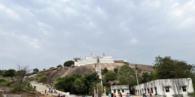
Hyderabad, September 21 (Najaf Ali Shoukat, PMI): The land of the historic Kohe Imam Zamin (A.S.) at Trimulgherry, Ammuguda, Secunderabad, has once again come under focus over land records, its Waqf status, alleged encroachments, government and defence use, and various court cases. Available records put the total extent of the land at 82 acres and 27 guntas. However, the key question remains: how much of this total area is still recorded as Waqf land today, and what is the present legal and physical status of the remaining land?
Available information indicates that there is currently no single, comprehensive, and updated government survey or status report providing a conclusive answer to these questions. This has led to growing calls for a fresh joint government measurement and survey of the entire 82 acres and 27 guntas.
How much of the 82 acres 27 guntas remains in Waqf records?
The Telangana Waqf Board, in various court proceedings, has relied on historical records, Muntakhab, Pahani and Gazette entries to maintain that the land associated with Kohe Imam Zamin (A.S.) is Waqf/service inam land.
According to the High Court record, the Waqf Board submitted that Muntakhab No. 13 of 1951 recorded an extent of 71 acres and 3 guntas as service inam land associated with Kohe Imam Zamin. The Waqf Board also claimed that Survey Nos. 66/1 and 66/2 constituted service inam/mafi inam land associated with Kohe Imam Zamin.
However, these historical records cannot by themselves be treated as a substitute for the present physical and legal status of the entire 82 acres and 27 guntas. The available records do not provide a comprehensive, updated government assessment showing how much land presently remains in Waqf records, how much has been acquired or transferred for other purposes, and how much is currently under the possession or use of different parties.
How much land was acquired for defence or other government purposes?
According to the position presented by the Waqf Board before the High Court, some of the Waqf land associated with Kohe Imam Zamin was acquired for defence purposes, and records relating to payment of compensation to the Waqf Board were also placed before the court.
However, the currently available material does not clearly establish how many acres and guntas out of the total 82 acres and 27 guntas were acquired for defence or other government requirements.
A definitive answer would require examination of acquisition awards, compensation records, survey-number-wise maps, and official records showing present possession and utilisation.
How much land has residential or commercial construction?
There is currently no updated official survey-wise data establishing the exact extent of land within the overall Kohe Imam Zamin property that is occupied by houses, buildings, commercial establishments or other structures.
Claims of large-scale encroachment have also been made by various quarters. However, without a recent comprehensive government survey covering the entire 82 acres and 27 guntas, it would not be appropriate to treat any particular percentage or area as conclusively encroached.
In particular, claims that 60 or 70 per cent of the land has been encroached upon have surfaced from time to time. However, no recent comprehensive government survey has been identified in the available records that conclusively verifies these percentages.
How much land remains open, hilly or in natural condition?
The main Kohe Imam Zamin (A.S.) shrine is located on a hill, while different types of land reportedly exist in the surrounding area. However, there is currently no updated government land-use survey categorising the entire 82 acres and 27 guntas into open, hilly, natural, built-up, water-body or other categories.
Such a classification can be conclusively established only through a joint ground survey.
How many portions are involved in court cases?
On January 27, 2026, the Telangana High Court delivered an important judgment concerning three writ petitions relating to Survey No. 66/1 at Trimulgherry.
According to the judicial record, the court examined several historical documents, including records relating to the old Survey No. 62, entries concerning Kohe Imam Zamin between 1920 and 1929, government resumption in 1929, subsequent auction proceedings and the 1951 Muntakhab.
The Waqf Board maintained before the court that Survey Nos. 66/1 and 66/2 constituted service inam/mafi inam land associated with Kohe Imam Zamin. The petitioners, on the other hand, relied on historical government records, auction proceedings and various claims concerning ownership.
The High Court allowed the three writ petitions and set aside the orders under challenge. However, it would not be correct to interpret this judgment as a final determination of the ownership or Waqf status of the entire 82 acres and 27 guntas. The judgment concerned a specific legal dispute, particularly relating to Survey No. 66/1.
What action was taken on the complaint submitted to HYDRAA in 2024?
On November 5, 2024, the Telangana Waqf Board reportedly approached HYDRAA regarding the Kohe Imam Zamin land, raising concerns over alleged unauthorised encroachments and alleged dumping into a water-body area belonging to the Waqf property.
The representation cited the total extent as 82 acres and 27 guntas and sought intervention to prevent further encroachment.
At the time, HYDRAA officials were reportedly informed about the matter and indicated that the issue would be examined and appropriate action considered.
However, the available recent material does not clearly establish what action was subsequently taken on the ground, how much land was measured, how many notices were issued, or whether any final action was taken against alleged encroachments or constructions.
This remains an important question that requires clarification from the concerned government agencies.
What did the Waqf Board do after the January 2026 High Court judgment?
In its January 27, 2026 judgment, the High Court set aside the orders challenged in relation to Survey No. 66/1.
The judgment provides detailed information about the facts of the case and the arguments advanced by the parties. However, complete and updated official information regarding any appeal, review petition, further legal proceedings or administrative action taken by the Waqf Board after the judgment was not available for this investigation.
Therefore, another important question is what legal strategy the Waqf Board adopted after the judgment, whether an appeal was filed, and what concrete measures were taken to protect the larger 82-acre-27-gunta property.
Need for a fresh joint survey
The Kohe Imam Zamin (A.S.) land issue has become complex because of historical records, multiple survey numbers, old Pahani records, Muntakhab and Gazette entries, government resumption, defence acquisition, existing constructions, and various legal disputes.
In this situation, it appears necessary for the Telangana Waqf Board, Revenue Department, HYDRAA and other concerned government agencies to conduct a fresh joint survey.
The survey should provide a survey-number-wise assessment covering the extent of land, recorded ownership/status, government or defence use, existing constructions, open land, alleged encroachments and pending litigation.
A comprehensive public status report or white paper on the 82 acres and 27 guntas could then clarify:
-
How much land is currently recorded as Waqf property;
-
How much land was acquired for defence or other government purposes;
-
How much land is occupied by residential or commercial constructions;
-
How much land remains open or in natural condition;
-
Which survey numbers or portions are involved in legal disputes;
-
The exact extent of alleged encroachments according to official measurements;
-
What action was taken on the 2024 HYDRAA complaint; and
-
What legal steps were taken by the Waqf Board following the January 2026 High Court judgment.
The actual present status of the Kohe Imam Zamin (A.S.) land can ultimately be determined not through claims or estimates, but through a fresh government survey, authenticated land records, survey-number-wise maps, and judicial orders. Such an exercise could help protect the historic Waqf property while also reducing future land disputes and unverified claims. (pressmediaofindia.com)