24-09-2023
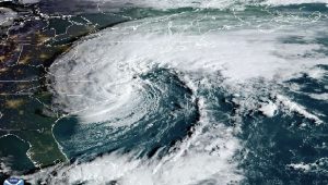
CAROLINA: Tropical Storm Ophelia is rapidly gaining strength off the East Coast, warranting heightened concern and preparations across the region.
 With maximum sustained winds reaching 70 mph and gusts even higher, the storm is set to impact areas far beyond its center, bringing heavy rainfall and strong winds in its wake.
As the storm makes its way north-northwest towards the East Coast at a speed of approximately 13 mph, a hurricane watch has been issued for specific areas of eastern North Carolina. Ophelia’s center is projected to approach North Carolina’s coast on Friday night, potentially posing significant challenges for coastal residents.
While the storm’s trajectory could bring it perilously close to the warm waters of the Gulf Stream, offering the possibility of additional strengthening, the most likely outcome remains intense rain and powerful winds as the storm heads towards eastern North Carolina.
Coastal regions are anticipated to bear the brunt of the storm, facing heavy rainfall, strong winds, and potential power outages. The threat is significant enough that North Carolina Governor Roy Cooper has declared a state of emergency across the entire state, ensuring that emergency response teams are ready to act swiftly.
Tropical storm warnings have been issued along the coast, from just south of Charleston, South Carolina, up to the Maryland-Delaware state line. Additionally, storm surge warnings stretch from Surf City, North Carolina, to the Chesapeake Bay, necessitating thorough preparations.
 Apart from the primary concern of heavy rain and wind, the region is also on alert for the potential development of tornadoes, primarily along the coastal mid-Atlantic.
Eastern North Carolina and southeast Virginia are expected to bear the brunt of the rainfall, with forecasts suggesting 3 to 5 inches of rain, and isolated areas potentially receiving up to 7 inches due to concentrated thunderstorm bands.
Residents of the mid-Atlantic to southern New England are advised to be vigilant, expecting 2 to 4 inches of rainfall from late Friday through the weekend.
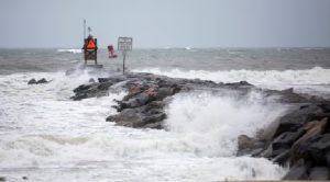
Coastal areas should also anticipate hazardous storm surge, coastal flooding, rip currents, and rough surf. Surge levels of 1 to 5 feet are a possibility in various areas, particularly in inlets and rivers from Surf City, North Carolina, to Manasquan Inlet on the New Jersey shore.
With the highest risk of storm surge flooding coinciding with Saturday’s high tides, areas from New Jersey to the Virginia Tidewater are urged to exercise caution.
Flood gauges across the region are expected to reach moderate or major flood levels on Saturday, highlighting the potential for homes and businesses closest to the coast to flood and for roads to become impassable. (Int’l News Desk)
 Pressmediaofindia


