
Related Articles


28-09-2024
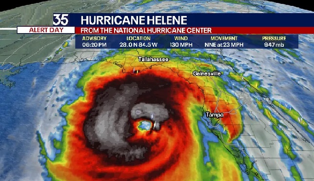
TALLAHASSEE: Hurricane Helene has been upgraded to a category four storm, with wind speeds of up to 130mph (215 km/h).
Helene is expected to make landfall in the Florida Big Bend area on Thursday.
Authorities warn it could bring a “catastrophic” and “unsurvivable” storm surge, where inundations could reach as high as 20 feet (6m) above ground.
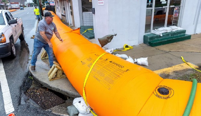
 Residents have been urged to evacuate and are warned that up to 18 inches of rainfall could bring flash flooding in some areas.
Tallahassee, Florida’s capital city of 200,000 residents, could be significantly impacted by the hurricane.
The sheriff’s office requested those who have evacuated to only return when given the all clear by the Emergency Operations Center.
“Many roads will be impassable, and there may be downed power lines, fallen trees, and other dangerous conditions,” the warning on social media states.
Taylor County is south-east of Tallahassee, on the Big Bend coastline where “catastrophic” storm surges are expected.
Denise O’Connor Badalamenti has lived in Florida for decades. She’s seen countless hurricanes but Helene has her more on edge than ever before.
“I think this is going to be the one,” the 62-year-old tells me from her Bradenton home, which sits blocks from the water. “I feel like we’re always in the cone of possibly being targeted but then get sparred at the last minute but I don’t think we’re going to get lucky again.”
Her mother’s home has flooded six times over the years and this morning, water was already creeping up their driveway. They taped up all the doors shut, hoping to stop any flooding.
“This one is just massive. It’s scary,” she tells me. She has stockpiled supplies and has an assortment of food ready if they lose electricity.
“We’re ready for the worst.”
 The National Hurricane Center has just updated its advice, external for the category four Hurricane Helene.
The “extremely dangerous” storm is nearing the northeast Gulf Coast and is currently about 80 miles (125km) off Cedar Key in Florida. It’s moving at 23mph (37km/h) and is expected to make landfall shortly.
The storm could strengthen before the eye reaches the coast.
Storm surge
There are storm surge warnings for Mexico Beach eastward and southward to Flamingo, Tampa Bay and Charlotte Harbor. The surge is expected to be as high as 15-20ft (6m) between Carrabelle and Suwannee River.
Residents are warned there will also be large and dangerous waves.
Powerful winds
Maximum sustained winds are near 130mph (215 km/h) with higher gusts. Residents are warned not to go outside if the winds are calm, because it would likely be the eye of the storm and powerful winds will follow.
Tornadoes
There is a tornado risk across Florida, southeast Georgia.
John Dailey, the mayor of Tallahassee, has just been speaking on media.
He says the city, Florida’s state capital, has been preparing all week for what’s about to come.
“If we have a direct hit with a category four hurricane, it will be the most powerful storm ever to hit the city of Tallahassee in written history,” he says. (Int’l Monitoring Desk)