Related Articles


21-08-2025
NASSAU: HISPANIOLA: Hurricane Erin slowly moved northward on Tuesday, triggering rough surf and dangerous rip currents along the East Coast that have already resulted in dozens of water rescues, swimming bans, and beach closures across the region.
 Hundreds of thousands of beach-going tourists were keeping a watchful eye on the massive hurricane as Erin was expected to produce life-threatening conditions for the Atlantic Coast from central Florida to Canada. The National Hurricane Center urged beachgoers in those areas to follow advice from lifeguards, local authorities, and beach warning flags.
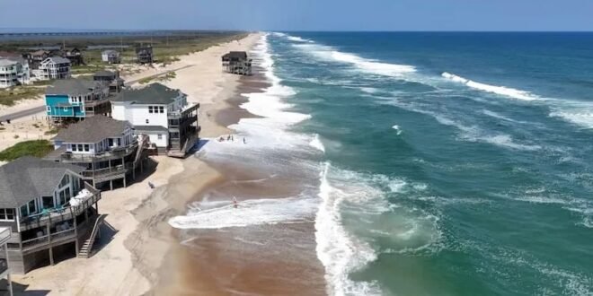
Evacuations were underway along parts of North Carolina’s Outer Banks, a big draw for vacationers every summer. North Carolina Gov. Josh Stein declared a state of emergency Tuesday afternoon “to assist with the response and to mobilize resources.”
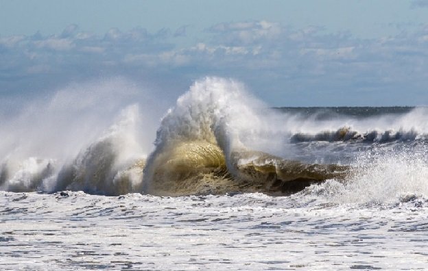
With Erin’s predicted storm surge and waves of over 10 feet, the National Weather Service advised people in the Outer Banks to stay out of the ocean to avoid deadly surf conditions expected through at least Thursday. Tropical storm conditions were forecast to arrive by Wednesday evening or night, the National Hurricane Center said.
“The storm surge will be accompanied by large waves, leading to significant beach erosion and over-wash, making some roads impassable,” the hurricane center said in its key messages at 11 p.m. ET.
Tropical storm conditions were also possible along the southeastern coast of Virginia where a tropical storm watch was in effect on Thursday, according to the hurricane center. The agency advised interests in the mid-Atlantic and southern New England coasts to monitor the progress of Erin due to potential strong winds on Thursday and Friday.
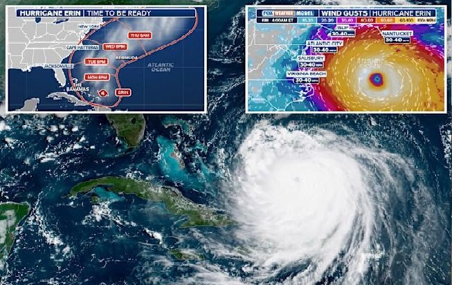
Erin was downgraded to a Category 2 hurricane earlier Tuesday but remained powerful, driving sustained winds of 100 mph by late night. Erin was moving north-northwest at nearly 12 mph, the National Hurricane Center said in an 11 pm ET advisory.
 The storm appeared to be making the long-forecast, slow cruise northward hundreds of miles offshore and no US landfall was forecast. Still, Erin’s large and expanding wind fields mean storm-driven waves, coastal erosion and high seas are expected to batter areas of the coast, especially along the Outer Banks, the barrier islands that fringe the coast of North Carolina.
Bermuda’s weather service issued a tropical storm watch for the archipelago which has seven main islands and a total population of 65,000.
Winds with tropical-storm force from Erin will probably extend outward more than 230 miles from its center, AccuWeather said. According to the outlet, wind gusts of 40 to 60 mph could impact parts of the mid-Atlantic and even southeastern Massachusetts as the storm heads north later in the week.
The National Weather Service office in the Baltimore/Washington area has issued advisories that include a coastal flood warning for Annapolis, Maryland, where flooding is expected within 36 hours.
Vacationers at beaches were forced to forgo the final days of summer sand due to swimming bans and beach closures in North Carolina, parts of New Jersey, Delaware, and New York City, as high waves and rip currents whipped up the surf.
New York Mayor Eric Adams said all the city’s beaches will be closed for swimming on Wednesday and Thursday “due to dangerous riptides from Hurricane Erin.” New Jersey Gov. Phil Murphy urged visitors and residents to avoid wading or swimming in the ocean, citing the dangerous rip currents and high waves. (Int’l News Desk)